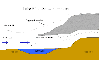
Lake-effect snow is simply snow that forms over a lake (in our case, Lake Ontario in the Great Lakes) due to the difference between the temperature of the lake surface and the air directly above it. Lake-effect snow occurs at large lakes all over the world, but is perhaps most prominent over the North American Great Lakes. In late autumn or early winter, before the lakes freeze over, very cold airmasses from Canada will occasionally swing down over the Great Lakes, bringing frigid temperatures to the region. The air might be 10-20 degrees Fahrenheit, while the lake water temperature might still be 40-50 degrees. This creates a situation where the lake water is much, much warmer than the air flowing over it.
Most of us know that warm air rises as long as it is warmer than the air around it. As the cold air flows over the much warmer lakes, the air in contact with the water will warm due to conduction and will also pick up lots of moisture from the lake itself. This creates a layer of relatively warm, humid air right above the water which eventually begins to rise through the cold, dry air around it. Just like with summertime thunderstorms, this rising warm air eventually cools off to the point that condensation can occur, forming a cloud, and eventually snow. If the warm air is rising fast enough, and contains enough moisture, then the snow that forms in the cloud can become very heavy in a very short period of time. This is illustrated in the photo below.
Lake-effect snow can take two general forms, depending primarily on the fetch (distance the cold air has to travel over the water) over the lake. Because the longest axis of Lake Ontario is from west to east, the wind has to be going from west to east as well to create the longest fetches. In these types of long-fetch situations, a single, thin band of heavy snow often develops over the lake parallel to the wind direction. This snow band will usually move eastward off the lake and dump huge amounts of snow over the eastern shores and even farther inland.
 |
| Satellite image of a single long-fetch lake-effect snow band |
 |
| Multiple lake-effect snow bands over Lakes Superior and Michigan |
Some of the questions we are trying to answer during this research project relate to what the winds are like near these strong snow bands, how these snow bands keep their strength and intensity once they move off of the lake to the east, and what exactly is going on in the clouds to cause the snowfall to become so intense in the first place? Because of how intense these storms can get, and because they often impact many people, it is crucial to be able to understand as much as we can about how they form so we can forecast them more effectively and prepare for when they occur.
Below are a few more photos related to lake-effect snow that you may find interesting. I will hopefully be adding more photos to this page as the project continues, including perhaps a few of my own lake-effect snow photos!
 |
| Average winter snowfall (inches) across upstate New York. Lake Ontario is at the top |
 |
| Total lake-effect snowfall (inches) from the 10-day storm in February 2007. Note how small the area is that received the most snow |
 |
| Lake-effect snow aftermath in Oswego, NY (Photo by Dave Kelly) |
 |
| Lake-effect snow clouds in the distance |
P.S. We will be having our first official IOP (Intensive Operations Period) tomorrow afternoon (Saturday, Dec. 7). In other words, the first OWLeS lake-effect event is about to happen. Unfortunately, I will not be flying in the King Air this time. But next week looks much more promising for a strong lake-effect event, during which I will most likely be on the plane! Stay tuned...

No comments:
Post a Comment